Google has been actively updating and adding new features for Google Maps in India. It recently added a feature that enables users to report a ‘slowdown’ on Indian roads. The company has now announced three new features for Google Maps users in India, which are aimed at commuters and people who use public transportation as their main mode of transportation. Google Maps will now show live train status for Indian Railways trains, along with bus travel times from live traffic in 10 of the largest Indian cities. Users will also see mixed-mode commuting suggestions, which combines auto-rickshaw and public transport.
The real-time train information for long-distance trains will enable users to see at what time a train is arriving. The feature will also display live train status for Indian Railways trains and has been developed in partnership with the Where is My Train app, which was acquired by Google last year. One can use this option by booting up Google Maps, and searching and selecting their starting station and destination station. Users will see a list of trains that are available between the selected route and here, real-time status of trains will be shown, along with additional information like delays.
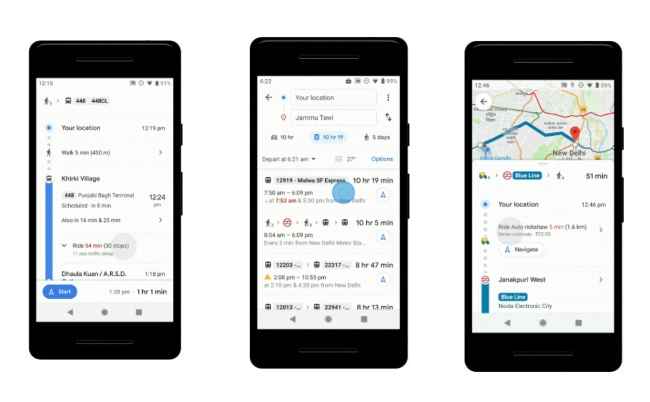
Google Maps is also being updated with an option to display bus travel times based on current live traffic conditions. The feature is apparently made possible by leveraging Google’s live traffic data and public bus schedules to “calculate delays and provide accurate travel times.” As mentioned above, this new option will be available for 10 Indian cities like Mumbai, Delhi, Bangalore, Hyderabad, Pune, Lucknow, Chennai, Mysore, Coimbatore, and Surat. Google states in its blog post, “This is the first product of its kind -- launching first in India -- enabling you to know how long your bus trip will take when factoring in live traffic conditions,” One can look up live bus travel times by tapping on the transit tab after entering their starting location and destination.
The public transport option on Google Maps for Android will now notify users of directions in mixed mode for journeys that combine auto-rickshaw rides and public transport. It will show options like commute times, which station to take an auto-rickshaw to/from, estimated rickshaw meter fare and departure times for your transit connection. This new feature is initially rolling out for commuters in Delhi and Bangalore and is slated to be made available soon in more cities.
from Latest Technology News http://bit.ly/2WNOehw


No comments:
Post a Comment